Enabling a GEO-NGEO Hybrid System
Jul 11th, 2018
by
Shagun Sachdeva, NSR
The Military segment has, historically, primarily
been served by GEO satellites for execution of
critical applications, including intelligence
gathering, navigation and communication. GEO
systems, by nature, offer the advantage of
significant coverage via a single satellite,
especially with the advent of GEO-HTS satellites.
On the other hand, latency and significant CAPEX
have always been limitations of the GEO
architecture. These drawbacks have given rise to the
emerging trend of LEO and MEO constellations (NGEO)
that can offer low latency and lower cost per
satellite. However, constellations have their own
set of constraints, with system complexity, ground
infrastructure costs and frequency spectrum
coordination, to name a few. Considering both, the
shortcomings as well as the strengths of each
system, could this perhaps be the start of an
integration between GEO and LEO/MEO operators with a
hybrid GEO-NGEO system on the rise?
Military users - at the most fundamental level -
strive for low cost, secure and robust solutions and
NGEO constellations, conceptually, checks all the
boxes. Following this rationale, DARPA’s recently
announced Blackjack program, that is designed with
the goal to develop a low Earth orbit constellation
with low cost, mass producible space payloads and
satellite buses, makes absolute sense. NGEO systems,
by design, come with a distinct advantage of being
more resilient towards enemy attacks and are easier
to rehabilitate if penetrated. Security against
espionage and cyber-attacks is another major
pre-requisite for military systems, and this is
where the new constellation models such as those
proposed by LeoSat and Telesat play a significant
role. The highly secure mesh network concept offered
by these enterprises are ideal for military
applications and make for an optimal solution for
ideas like the recently announced military “space
force”. Keeping the overall system costs low,
however, is where it gets complex for NGEO
framework. Although the manufacturing and launch
costs per satellite are relatively lower, the need
for a considerable number of satellites, the
associated replenishment costs and the ground
infrastructure expenses – all intensify the overall
system cost.
NSR’s recently published Satellite Constellations: A
Critical Assessment report conducted an extensive
analysis of the various NGEO constellations. Their
expected capital and operating expenses as well as
the possible revenue streams for each were
considered to establish expected ROIs over a 10-year
period. While NSR believes that some of the
constellations studied have an imposing business
model that closes the current market gaps
seamlessly, as it currently stands, it also
concludes that it will be challenging for most to
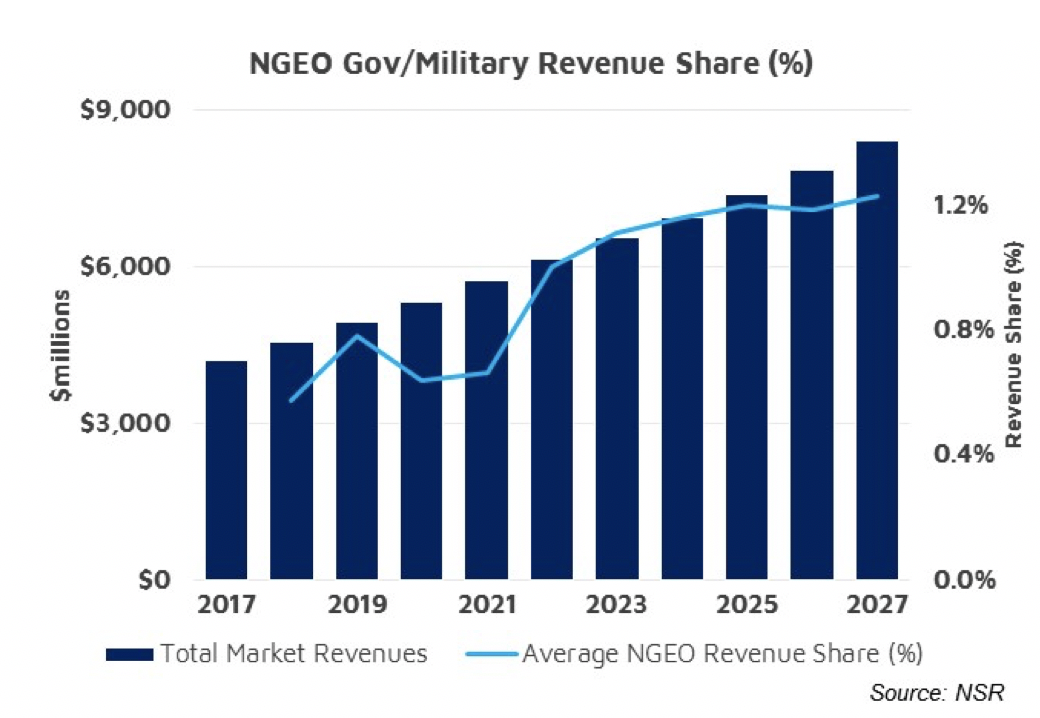
close their business case. As such, NSR estimates
just over 1% of total revenues for gov/military will
come from Non-GEO constellations by 2027.
The total cost of ownership (TCO) is a key driver
for NGEO constellations, military and otherwise, and
is as well one of the biggest challenges for the
operators presently. Simply put, either the
expenses, mostly CAPEX, need to drop or the revenues
need to grow for the business case to sustain. This
is where a GEO-NGEO Hybrid architecture could prove
pragmatic.
This integration of GEO and NGEO systems can
materialise at two levels: Mergers & Acquisitions
(M&A) and strategic partnerships between GEO and
NGEO operators, both of which are great ways to
optimise revenues from GEO and NGEO systems by
diligent bandwidth management. Intelsat’s and
OneWeb’s unsuccessful attempt towards a strategic
alliance was one example of this hybrid system. GEO
operators JSAT and Hispasat have similarly announced
strategic investment in LEO constellations including
LeoSat. In addition to offering higher revenues with
comparably less system complexity, GEO-NGEO systems,
by complementing each other, can further offer
customised solutions for customers. SES is already
well on their way in this regard with the O3b
constellation and the oncoming next-gen mPOWER
satellites.
Another level of integration, perhaps more
technically innovative, and therefore challenging,
is a system where GEO satellites can handle the TT&C
operations for LEO constellations and act as the
base station control system of the network. This,
naturally, is pertinent to the low latency-dependant
applications. Arguably, latency is a little
over-stated when it comes to NGEO constellations.
Suffice it to say that a considerable number of
services offered by NGEO constellations do not
require low latency as a priority. For such cases,
successful implementation of this type of
integration can result in reduced number of ground
stations, thereby reducing the overall system
complexity and associated costs.
However slow-paced or technologically immature these
concepts, there seems to be an undeniable move
towards a GEO-NGEO hybrid system – leading to an
integration of the players in the two orbits.
The Bottom Line
With an increasing demand for more service and an
unceasing need for the latest technology, both while
keeping the costs low, hybrid Commercial-Military
architectures have already become an unavoidable
solution for the Military. Manufacturers can offer -
what would otherwise need to be customized products
– (nearly) Commercial Off the Shelf (COTS) solution
for Military sector, thereby keeping the costs low
while meeting the requirements. This sharing of
products and services between Commercial and
Military segments has resulted in an integration at
the industry level.
Looking further into the Military sector and their
need for low cost, low latency and a robust
solution, a hybrid GEO-NGEO system is the natural
step forward for Military sector. GEO satellites
offer simplicity and lower ground investment, while
NGEO yields a low latency and a highly resilient
solution against Anti-satellite Weapons (ASAT). From
Blackjack to Space Force, the latest developments in
government and military space sector are a potential
step towards an integration at the orbital level.